Chihuahua

Pronunciation: chee-WAH-wah.
Origin of state name: Uncertain. May come from the Nahuatl word for "dry, sandy place."
Capital: Chihuahua.
Entered country: 1824.
Coat of Arms: The coat of arms is shield-shaped, with a red border. Across the top is a depiction of the old aqueduct of Chihuahua. In the center section a head of a Spaniard (left) and an Amerindian (right) represents the mestizo, or blending of two peoples; the lower third depicts Chihuahua Cathedral.
Holidays: Año Nuevo (New Year's Day—January 1); Día de la Constitución (Constitution Day—February 5); Benito Juárez's birthday (March 21); Primero de Mayo (Labor Day—May 1); Revolution Day, 1910 (November 20); and Navidad (Christmas—December 25).
Flag: There is no official flag.
Time: 5 AM = noon Greenwich Mean Time (GMT).
1 Location and Size
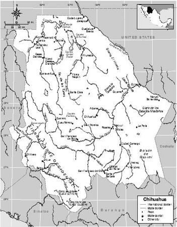
Chihuahua, the largest state, lies in northern Mexico. It has an area of 245,945 square kilometers (94,960 square miles), about one-third the size of the US state of Texas. Chihuahua is bordered on the north by the US states of New Mexico and Texas, on the south by the Mexican state of Durango, on the east by the Mexican state of Coahuila, on the west by the Mexican state of Sonora, and on the southwest by the Mexican state of Sinaloa. Chihuahua has sixty-seven municipalities. Its capital is also called Chihuahua.
The natural regions of Chihuahua are plateau and mountains ( sierras ). Chihuahua's sierras have steep peaks with narrow gorges. The rest of the state is made up of high plateau.
Rivers run generally west from the mountains and reach the Golfo de California. Rivers include the Papigochic, Urique, Batopilas, and Basasseachi. The Conchos River joins the Río Bravo (known as the Rio Grande in the United States) along the Texas border. The Río Bravo flows east to the Gulf of Mexico.
2 Climate
The climate is dry to semi-arid although there is regular rainfall. The average annual temperature is 20° c (68° f ). Annual rainfall ranges from 221 millimeters (8.7 inches) to 1,023 millimeters (40.3 inches).
3 Plants and Animals
In the high plateau region and on the plains, native plants include lechuguilla (an evergreen succulent), mesquite (a common desert shrub), guayule (a rubber producing plant), and ocotillo (a succulent plant with red flowers). Native animal life includes lizards, rattlesnakes, and small birds and animals such as quail, shrews, rabbits, squirrels, skunks, wild boars, and porcupines.
In the mountains ( sierras ), native plants include pine and fir trees, poplars, and white cedar trees. Native animals include bats, moles, rats, bears, white-tailed deer, wolves, gray foxes, raccoons, and squirrels. There are nearly three hundred species of migratory and native birds, including spotted owls and blue-throated hummingbirds, along with over eighty species of reptiles.
4 Environmental Protection
Chihuahua has air quality problems in certain areas where there is heavy traffic. Many roads are not paved, and trucks create dusty conditions. In the border area around El Paso, Texas, and Ciudad Juárez, Chihuahua, safety of the water supply is sometimes threatened. The Conchos River, which eventually joins the Río Grande, is polluted by waste water. After the North American Free Trade Agreement (NAFTA) was passed in 1992, the Border Environmental Cooperation Commission (BECC) was created to protect the environment in the border areas where development was rapid.
5 Population, Ethnic Groups, Languages
Chihuahua had a total population of 3,052,907 in 2000; of the total, 1,519,972 (49.8%) were men and 1,532,935 (50.2%) were women. The population density was 12 people per square kilometer (31 people per square mile). In 2000, the capital, Chihuahua, had a population of 670,208. Most people in Chihuahua speak Spanish, but a small percentage (3.2%) speak indigenous languages. About 85% of the indigenous language-speakers are Tarahumara.
6 Religions
According to the 2000 census, 72% of the population, or 2.2 million people, were Roman Catholic; 6%, or 185,665 people, were Protestant. That year there were also 5,817 Seventh-Day Adventists, 12,016 Mormons, 34,006 Jehovah's Witnesses, and over 160,000 people who reported no religion.
7 Transportation
The network of highways and roads is over 16,985 kilometers (10,615 miles) and connects all parts of the state. Over 2,200 kilometers (1,375 miles) of railroad serves the state, especially the tourists areas. By the end of 1910 there were three rail lines in operation. In 1961, the completion of the Chihuahua-Pacifico, known as ChP or Chepe, changed life in Chihuahua. Now remote areas could be reached and both mining and tourism expanded. In 1998, Ferromex, a private company, took over
There is an international airport in the city of Chihuahua.
8 History
When the Spaniards first arrived, Chihuahua was inhabited by more than one hundred different indigenous groups. Among them were the Taraumara , Apache, Comanche, and Guarojío . The first Spaniard to visit was Alvar Nuñez Cabeza de Vaca, whose expedition covered territory from the US state of Florida to the Mexican state of Sinaloa.
The first Spanish settlements date back to the 16th century, when haciendas (country estates) and mining centers were first established. Some Franciscan (Roman Catholic) missions and the Carapoa villages (which are now a single town) were also founded in the mid 1500s. In 1598, the military garrisons known as El Paso and Ciudad Juárez were first built. Yet, the Spanish colonizers only loosely controlled the region during most of the 16th century.
The growth of the mining industry in the 17th century generated more economic activity but also provoked more indigenous uprisings. Tensions developed between the miners and the hacienda owners, who were interested in forcing indigenous groups to work as slaves. The interest Roman Catholic priests had in converting the indigenous people motivated several interventions by the Spanish crown to reduce tensions in the region.
The Independence War provoked Chihuahua hacienda owners and miners to side with the royalist forces against the independence movement. Yet, by 1821 the inevitable Mexican independence led leaders in Chihuahua to join the new country. The Plan of Iguala of 1821 established the framework that consolidated the new republic. Later, the region of Durango was separated from Chihuahua to create a new province. Chihuahua officially became a state of Mexico in 1824. The first state constitution was ratified in 1825.
An ethnic war that sought to exterminate Apache and Comanche indigenous people in 1830 caused much bloodshed. It almost entirely achieved its goal, nearly wiping out the indigenous population. After Texas achieved independence, Chihuahua resisted an effort to annex the state to the United States. Yet, the Treaty of Guadalupe Hidalgo in 1848 gave the United States a significant part of a territory previously considered part of Chihuahua. With the help of Chihuahua's governor Luis Terrazas, liberal national leader Benito Juárez (1806–1872) resisted the French occupation in Chihuahua in the mid-1860s.
Chihuahua was a central battleground during the Mexican Revolution (1910–1920). There was discontent against the Díaz regime, but the historic tensions with neighboring Coahuila, Madero's home state, were strong as well. This tension prevented the discontent against the central government from becoming a fueling force for the revolution in Chihuahua. Yet, even the United States sent troops to the state and occupied it for almost a year. Peasant revolutionary leader Francisco Villa (1878–1923), known as Pancho Villa, extensively fought in Chihuahua. He demanded land distribution and recognition of the peasants as legitimate actors in Mexican politics. Villa's famous military Northern Division was first assembled in Chihuahua.
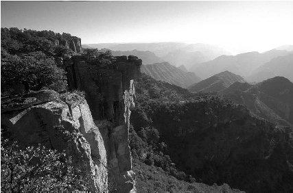
Copper Canyon.
After the revolution, Chihuahua remained a center of Institutional Revolutionary Party (PRI) influence. Its location close to the United States made it a strategic state for Mexico. It also allowed for the development and eventual consolidation of the oldest and most important opposition party during PRI rule, the National Action Party (PAN). Chihuahua leader Luis H. Álvarez became the PAN presidential candidate in 1958, after an unsuccessful run for the state governorship. This showed Chihuahua's emergence as a center of active political opposition against the ruling PRI. Economic development was strong in the cities and along the Texas border during the 1960s through the 1990s, but people in rural areas continued to live in poverty.
In 1992, Chihuahua was one of the first states to elect a governor who was not a member of the PRI. The North American Free Trade Treaty (NAFTA), a trade agreement between Mexico, the United States, and Canada, was signed in 1992 and took effect in 1994. Because Chihuahua shares a border with the United States, much economic development occurred in the state after NAFTA was signed. However, small farmers found it difficult to compete in the North American competitive market.
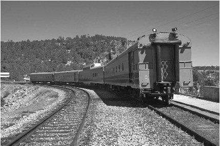
The Chihuahua Pacifico Railway.
9 State and Local Government
The governor's office is powerful. The governor is democratically elected every six years for a nonrenewable term. In addition, a thirty-three-member state congress is comprised of members elected for nonrenewable three-year terms. Twenty-two of the members are elected in single member districts and eleven in proportional representation. Separation of power provisions have strengthened and consolidated since the election of a non-PRI governor in 1992. Politics in Chihuahua are among the most democratic among the Mexican states, since there are two strong parties.
Chihuahua is comprised of sixty-seven municipalities that vary in range and population. Elections for municipal presidents and council members are held every three years and immediate re-election is not allowed. The competitive nature of politics at the state level has allowed the development of strong municipal governments.
10 Political Parties
The three main political parties in all of Mexico are the Institutional Revolutionary Party (PRI), the National Action Party (PAN), and the Party of the Democratic Revolution (PRD). Chihuahua was the second state in Mexico to elect a non-PRI governor in the post-revolution period. After a contested election in 1986 where the PRI candidate emerged as winner, PAN's Francisco Barrio won the 1992 gubernatorial election. In 1998, Patricio Martínez García, a PRI militant, was elected governor, demonstrating the consolidation of a two party system in the state.
11 Judicial System
The Superior Tribunal of Justice is the highest court in the state. By law it must be made up of at least nine members. They are appointed by the legislature from a three-person list submitted by the executive in consultation with the legislature. Once ratified after their first three-year period, justices cannot be removed until a mandatory retirement age of 65. In addition, there is an electoral tribunal. Local courts complete the state judicial system.
12 Economy
Timber production and raising livestock were once the main components of the economy, but they represented less than 10% of economic activity as of 2003. Maquiladoras (assembly plants) that produce electronic components, automobile parts, and textile goods are now the primary economic activities. Manufacturing makes up about 23% of the economy. There are also a number of large breweries in the state. Tourism is an important and growing segment of the economy ever since railroad travel to the Copper Canyon area was upgraded following privatization of the railroad in 1998.
People living along the border often find barely enough water for drinking and cooking. There is much poverty in rural areas.
13 Industry
Over 350 maquiladoras (assembly plants) produce electronics, automobile parts, and wood products. Manufacturers such as Toshiba, JVC, and Honeywell have facilities in the many industrial parks that have been developed in the state. Chihuahua has one of the fastest growing economies in the country.
14 Labor
Labor-management relations in Chihuahua are generally good. Since the 1980s, the state's workforce has been known for producing high-quality products. The US Bureau of Labor Statistics reported that Mexican workers saw their wages increase 17%, from $2.09 per hour in 1999 to $2.46 per hour in 2000. (The average US worker earned $19.86 per hour in 2000.) After one year, workers are entitled by law to six days paid vacation.
After the North American Free Trade Agreement (NAFTA) was signed in 1992, relations between management and labor have been strained in the state. Union membership in Chihuahua is declining.
15 Agriculture
Despite its arid (dry) climate, agriculture is an important segment of the economy. Chihuahua farmers in the semi-arid coastal areas to the west produce sugar cane, oats, potatoes, wheat, cotton, corn, sorghum, peanuts, soy, alfalfa, and green chilies. In the valleys of eastern Chihuahua, farmers raise peaches, melons, nuts,
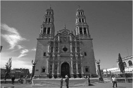
The Roman Catholic cathedral in the capital, Chihuahua, is built of pink stone. It took almost 100 years to complete.
Ranchers raise both beef and dairy cattle, as well as pigs, goats, and sheep on a smaller scale. Chihuahua is also an important producer of milk and cheese.
16 Natural Resources
Forestry is an important economic activity in Chihuahua. Chihuahua has been known for its timber resources and livestock.
Chihuahua is known for its gold and silver mines. It is the country's second largest silver producer after Zacatecas. Silver, lead, and zinc are produced at the Naica mine. Grupo Mexico operates two lead zinc mines, which both produce silver as a by-product.
Petroleos Mexicanos (Pemex), the state oil company, is the world's fifth largest oil company and the single most important entity in the Mexican economy. Pemex's natural gas pipeline connects to the US natural gas pipeline at nine locations, crossing the border into California, Arizona, and Texas (at the Chihuahua border at Ciudad Juárez, among other locations).
17 Energy and Power
Mexico's first geothermal (using heat from the earth's interior) power plant began operation in 1973 at the Cierro Prieto in Chihuahua, near the US border. In the late 1990s, the government-owned Comision Federal de Electridad (Electric Commission or CFE) raised prices for electricity, triggering widespread protests.
18 Health
The state of Chihuahua has 38 general hospitals, 530 outpatient centers, and 86 surgical centers.
Most of the Mexican population is covered under a government health plan. The IMSS (Instituto Mexicano de Seguro Social) covers the general population. The ISSSTE (Instituto de Seguridad y Servicios Sociales de Trabajadores del Estado) covers state workers.
19 Housing
As of 2000, 66% of the housing in Chihuahua was considered in need of only minor repairs or of no repairs. About 24% needed moderate upgrading, while 11% needed to be replaced or completely remodeled.
20 Education
The system of public education was first started by President Benito Juárez in 1867. Public education in Mexico is free for students ages six to sixteen. In 2000, there were about 638,067 school-age students in the state. Many students elect to attend private schools rather than the government-funded public schools. The thirty-one states of Mexico all have at least one state university. The Universidad Autónoma de Chihuahua celebrated its fiftieth anniversary in 2004.
21 Arts
Chihuahua has many theaters including an open air theater, el Teatro de Camara del Instituto de Bellas Artes, and el Teatro de Héroes, an older theater of Victorian design that hosts operas, plays, music, and various types of theatrical presentations.
22 Libraries and Museums
Chihuahua has 145 branches of the national library. There are many museums in Chihuahua including one dedicated to the history of the Mexican Revolution, a museum of modern art, a museum of sacred art, a museum of 19th century art, and a telephone museum.
23 Media
The capital city, Chihuahua, has three papers: El Diario, El Heraldo de Chihuahua, and Tiempo. The city of Ciudad Juárez publishes El Diario, and the city of Parral has El Sol de Parral.
24 Tourism, Travel, and Recreation
The city of Creel is the entryway to the western Sierra Madre mountain range known as Copper Canyon (Barranca del Cobre or Sierra Tarahumara). There are many tours of this region, which has six massive gorges that form a canyon system that is four times as large as the Grand Canyon of the United States. Four of the six canyons are deeper than the Grand Canyon. Copper Canyon takes its name from the copper-colored lichen (a type of mossy plant) that grows on the canyon walls. The culture of the indigenous Tarahumara people also attracts tourists to the area.
25 Sports
The city of Chihuahua has a basketball team, Los Dorados, which plays at the 1,500-seat Gimnasio R. M. Quevedo. There is also a 7,500-seat bullfighting ring. Ciudad Juárez has a baseball team (Los Gallos de Pelea) and a 15,000-seat bullfighting ring in the Plaza Monumental.
26 Famous People
Francisco "Pancho" Villa (1878–1923) was not born in Chihuahua but earned his reputation as a revolutionary leader in Chihuahua and Durango. Actor Anthony Rudolph Oaxaca Quinn (1915–2001) was born in Chihuahua but moved at age four to Los Angeles, California. His films included Zorba the Greek and Lawrence of Arabia. David Alfaro Siqueiros (1896–1974), a well-known muralist, has works at the National Preparatory School, Mexico City, and the Plaza Art Center in Los Angeles, California.
27 Bibliography
Books
DeAngelis, Gina. Mexico. Mankato, MN: Blue Earth Books, 2003.
Fisher, Richard D., et al. The Copper Canyon, Chihuahua, Mexico. Tucson, AZ: Sunracer, 2003.
Supples, Kevin. Mexico. Washington, DC: National Geographic Society, 2002.
Web Sites
Mexico for Kids. http://www.elbalero.gob.mx/index_kids.html (accessed on June 15, 2004).