Tamaulipas

Pronunciation: tah-mah-ooh-LEE-pahs.
Origin of state name: Name comes from the Huasteca word tamaholipa. It means either "where people pray" or "high mountains."
Capital: Ciudad Victoria (see-oo-DAHD veek-TOH-ree-ah).
Entered country: October 3, 1824.
Coat of Arms: The images on the coat of arms represent the economic activities of the state. Cornstalks and animals represent agriculture and livestock. The boat and the dock that appear on the lower half of the coat of arms represent fishing and industry. Cerro de Bernal, a well-known natural peak, is also shown in the lower part of the shield. The smaller shield in the top section represents the family coat of arms of José Escandón y Helguera, Count of Sierra Gorda, who colonized the state.
Holidays: Año Nuevo (New Year's Day—January 1); Día de la Constitución (Constitution Day—February 5); Benito Juárez's birthday (March 21); Primero de Mayo (Labor Day—May 1); Revolution Day, 1910 (November 20); and Navidad (Christmas—December 25).
Flag: There is no official state flag.
Time: 6 AM = noon Greenwich Mean Time (GMT).
1 Location and Size
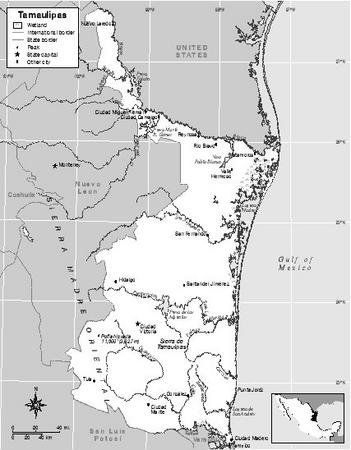
Tamaulipas covers an area of 79,829 square kilometers (30,822 square miles), which is a little smaller than the US state of South Carolina. It lies in the northeast corner of Mexico in the region known as the Independent North. It is bordered on the north by the US state of Texas, on the south by the Mexican states of San Luis Potosí and Veracruz, on the east by the Gulf of Mexico, and on the west by the Mexican state of Nuevo León. Tamaulipas has forty-three municipalities. Its capital is Ciudad Victoria.
Tamaulipas has hills and plains in the northern, central, eastern, and southeastern regions. There are large mountain ranges ( sierras ) in the western and southwestern regions. These include the Sierra Madre Oriental, where the highest mountains in the state
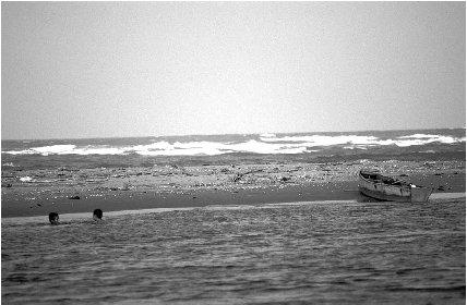
People enjoy a refreshing swim in one of the state's rivers. All rivers rise in the mountains and run into the Gulf of Mexico.
The most important rivers are the Bravo (or Grande), Conchos, Soto la Marina, Guayalejo, and Pánuco . All of these rivers rise in the mountains and run into the Gulf of Mexico. There are also lagoons, which are separated from the ocean by sand banks, all along the coast. The largest lagoon in Tamaulipas is the Laguna Madre.
2 Climate
The warm waters of the Gulf of Mexico contribute to the climate, which is generally warm and humid. The average temperatures is 24° c to 28° c (76° f to 82° f ). The highest monthly average rainfall occurs in August and September. In Ciudad Victoria, the average year-round temperature is 24° c (75° f ). The average rainfall in this city is 70 centimeters (28 inches) per year.
3 Plants and Animals
Trees found in the state include mesquite, pine, and oak forests. Cacti, orchids, and bromeliads are found in some areas. Large mammals found in the state include white-tailed deer, wildcats, jaguars, and bears.
4 Environmental Protection
Environmental issues such as hazardous waste disposal and safe water supplies are concerns within the state. In 2003, the state government was considering setting up a system that would require industries to monitor their environmental pollutants. The El Cielo Biosphere Reserve is a protected cloud forest, which is a tropical rain forest in the mountains that has nearly constant cloud cover . Playa Tortuguera Rancho Nuevo is a wildlife reserve that has been designated as a Wetland of International Importance by the international conservation group known as the Ramsar Convention.
5 Population, Ethnic Groups, Languages
Tamaulipas had a total population of 2,753,222 in 2000; of the total, 1,359,874 were men and 1,393,348 were women. The population density was 34 people per square kilometer (88 people per square mile). In 2000, the capital, Ciudad Victoria, had a population of 262,686.
Almost all citizens speak Spanish as their first language. Less than 1% of the population speaks indigenous (native) languages.
6 Religions
According to the 2000 census, 73% of the population, or two million people, were Roman Catholic; 8%, or 210,021 people, were Protestant. That year there were also 8,148 Seventh-Day Adventists, 10,094 Mormons, 39,461 Jehovah's Witnesses, and over 140,000 people who reported no religion.
7 Transportation
Ciudad Victoria Airport, Matamoros International Airport, and Nuevo Laredo-Qetzalcoatl International Airport provide international flights to and from Tamaulipas. The state has about 7,056 kilometers (4,383 miles) of roads and about 968 kilometers (601 miles) of railroads.
8 History
Archeological findings in the Cueva del Diablo caves point to human presence in the region as early as 6000 B . C . However, sedentary settlements date back to about 4000 B . C . First populated by Olmec groups, Tamaulipas was then populated by Chichimec and Huasteco groups. Between 1445 and 1466, Mexica armies commanded by Moctezuma Ilhuicamina conquered much of the territory and transformed it into a tributary region for the Mexica empire. Yet, Comanche, Apache, and other indigenous groups remained in rebellion against the invaders from central Mexico and were never conquered.
The first Spaniards to arrive were led by Francisco Hernández de Córdoba in 1517. Huasteco Indians defeated them. A new expedition led by Francisco de Garay was defeated a year later. In 1522, Hernán Cortés (1485–1547) defeated the rebel Indians and took control of the city of Chila. The lack of mineral deposits and the hostility of the indigenous people discouraged the Spaniards from attempting to expand their control to the northern end of the region. A number of efforts to convert the Indians to Catholicism also failed during most of the 16th century.
Early in the 17th century, Franciscan priests established missions in the region and began converting some of the sedentary populations. Cattle and sheep ranching brought increased economic activity to the region. Ranching also caused massive displacement of native populations from their original lands. Occasional indigenous revolts weakened colonial interest in the region. The presence of French colonizers in what would become the US state of Louisiana provoked concern among Spanish authorities in the 18th century. This French presence motivated a number of initiatives to populate the region and promote new economic activities. However, the reduced population and the lack of efficient transportation to the rest of Mexico hindered the economic development of the region.
Although some insurgent efforts were made to expand the independence movement to the region in 1810, Spanish royalist troops succeeded in preventing their success. The Plan of Iguala in 1821 ultimately incorporated Tamaulipas, which was made into a federal state in 1824. In 1836, nationalist troops from Tamaulipas fought against Texas secession. After the Mexican-American War (1846–48), Tamaulipas lost all of its territories north of the Rio Grande River to the United States. Political instability characterized much of the remaining 19th century, until the state began to experience economic development during the "Porfiriato era" (1876–1910), when president Porfirio Díaz (1830–1915) was in power.
The Mexican Revolution, which began in 1910, also reached Tamaulipas. As in the rest of Mexico, once the victors successfully agreed on a new national constitution, Tamaulipas was quickly brought into compliance. Emilio Portes Gil (1890–1978), governor of Tamaulipas during the 1920s, later went on to serve as president of Mexico between 1928 and 1930. During the rest of the 20th century, Tamaulipas consolidated its economy thanks to commerce with the United States. Since the adoption of the North American Free Trade Agreement (NAFTA)—a trade agreement between Mexico, the United States, and Canada—Tamaulipas has emerged as a manufacturing region for products exported to the United States. As one of the fastest growing states in the federation, Tamaulipas has benefited from the free trade reforms promoted by Mexico since the mid 1980s.
9 State and Local Government
The state governor is democratically elected for a nonrenewable six-year term. There is a unicameral (single chamber) legislature called the state congress. Nineteen of its twenty-six deputies are elected from single member districts and seven deputies are elected by proportional representation. All serve three-year terms without an option for immediate reelection. Because the Institutional Revolutionary Party (PRI), the dominant political party throughout the country since the end of the Mexican Revolution, has not faced sufficiently strong competition from other parties in the state, formal separation of powers provisions have not been actually enforced. Under these conditions, the governor exercises more powers and recognition than mandated in the constitution.
The forty-three municipalities that comprise Tamaulipas hold democratic elections
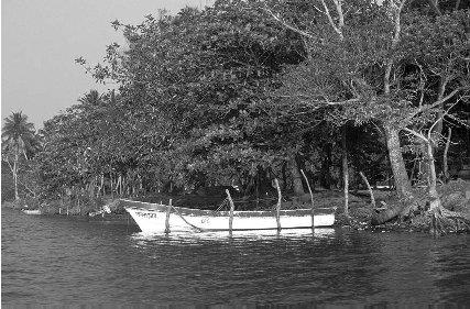
Boats on a river in southern Tamaulipas.
10 Political Parties
The three main political parties in all of Mexico are the Institutional Revolutionary Party (PRI), the National Action Party (PAN), and the Party of the Democratic Revolution (PRD). The PRI has dominated politics in Tamaulipas since the end of the Mexican Revolution in 1917. All governors elected in the state have belonged to that party. Tomás Yarrington was elected governor in 1999 for a six-year term. The PAN has emerged as the second strongest party in the state, but its strength is primarily located in urban areas.
11 Judicial System
The Supreme Tribunal of Justice is the highest court in the state. Its seven members are appointed by a two-thirds majority of the legislature from among a pool of highly qualified attorneys with demonstrated experience and competence. If justices are ratified after their initial three-year appointments, they serve until their voluntary retirement. In addition, an electoral court and lower local courts also constitute the state's judicial system. Despite formal provisions that guarantee its independence, the overwhelming influence of the state governor has prevented the state judiciary from being more independent.
12 Economy
Agriculture, fishing, and tourism are primary economic activities. However, manufacturing accounts for about 21% of the economy. Trade activities account for about 19% of the economy, followed by service-based companies at 17%, transportation and communications at 14%, finance and insurance at 13%, agriculture and livestock at 9%, construction at 6%, and mining at 1%.
13 Industry
About 350 assembly plants ( maquiladoras ) are located along the border with the United States. Over 150,000 workers are employed in maquiladoras. In the southern part of the state, chemical and oil production facilities manufacture acrylic fiber, plastic resins, synthetic rubber, and polymers.
14 Labor
The US Bureau of Labor Statistics reported that Mexican workers saw their wages increase 17%, from $2.09 per hour in 1999 to $2.46 per hour in 2000. (The average US worker earned $19.86 per hour in 2000.) After one year, workers are entitled by law to six days paid vacation.
15 Agriculture
Part of the fertile lowland area known as La Huasteca, Tamaulipas has the climate and conditions for agriculture. It is the main producer of sorghum in Mexico. Other major crops include corn, cotton, and wheat. More than half the state's land area is devoted to livestock. About 4.6 million hectares of pastures and meadows support over one million cattle, 250,000 goats, 200,000 pigs, and 110,000 sheep.
16 Natural Resources
The fishing industry is well developed because of the state's location on the Gulf of Mexico. The primary catch includes shrimp, crayfish, oysters, and crabs. Freshwater fish such as tilapia and catfish are also found in the state. There is also a thriving sport fishing industry serving tourists to the state. Oil is the primary mineral resource.
17 Energy and Power
Almost all of the energy in Mexico is provided by the Federal Electricity Commission (CFE). In February 2002, the CFE introduced new electric rates. For households that use less than 140 kilowatt hours per month, there was no rate increase. (This is about 75% of all households in Mexico, according to CFE).
18 Health
There are 36 general hospitals, 472 outpatient centers, and 90 surgical centers in Tamaulipas.
Most of the Mexican population is covered under a government health plan. The IMSS (Instituto Mexicano de Seguro Social) covers the general population. The
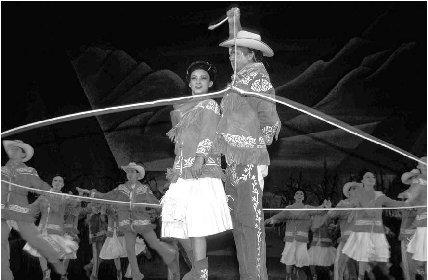
Typical dance from Tamaulipas.
19 Housing
More than one-half of the housing available in Tamaulipas is in good repair. More than 12% is in need of significant upgrading. Many homes do not have running water or access to electricity.
20 Education
The system of public education was first started by President Benito Juárez (1806–1872) in 1867. Public education in Mexico is free for students from ages six to sixteen. According to the 2000 census, there were approximately 556,000 school-age students in the state. Many students elect to go to private schools. The thirty-one states of Mexico all have at least one state university. Universidad Autónoma de Tamaulipas is located in Matamoros.
21 Arts
Tamaulipas has four major theater groups, including a mime theater. Most cities have a cultural center where local arts festivals and performing arts groups are showcased. There are also fifteen auditoriums located in various cities throughout the state. The International Festival of Tamaulipas, an arts festival, has attracted over one million attendees. The Centro Metropolitano de Tampico is a modern structure hosting experimental theater. A chorus made up of young people, Coro Meced Chimalli, presents concerts in the Palacio de Bellas Artes in the capital.
22 Libraries and Museums
There are one hundred branches of the national library system and seventeen museums in Tamaulipas. Matamoros has a museum of contemporary art. The capital, Ciudad Victoria, has an archeological museum. The Casamata Museum in Matamoros is a war museum.
23 Media
The capital, Ciudad Victoria, publishes the daily newspaper, El Mercurio de Tamaulipas. Nuevo Lardeo has two daily newspapers, El Diario and El Mañana. Reynosa also has two dailies: El Mañana de Reynosa and Hora Cero. Tampico's two newspapers are El Diario de Tampico and El Sol de Tampico.
24 Tourism, Travel, and Recreation
Matamoros lies on the border with the United States and attracts many tourists, many of whom like to shop in the marketplace. It is the official sister city to Brownsville, Texas. Many people come to shop in the Juarez marketplace. Playa Bagdad is also a popular beach getaway. Reynosa, a center for arts and crafts, also features a beach area, Las Playas, which is attractive to tourists. In Nuevo Laredo, there is a greyhound racetrack and a market where hand-blown glass is sold. The Nuevo Laredo Fair is held in early September each year. Tampico has a marketplace where beach and ocean-related handicrafts are sold. Sport fishing enthusiasts visit the state each year for the Golden Sea Bass tournament, held the week before Easter. Near Tampico in Madero, one can go to Miramar Beach.
25 Sports
Two cities in Tamaulipas have basketball teams. Matamoros hosts the Correcaminos de la Universidad Autónoma de Tamaulipas, while the city of Victoria hosts a team called the Correcaminos de Victoria. The city of Matamoros also has a Plaza de Toros, which can hold 7,000 spectators. The city of Nuevo Laredo hosts a professional baseball team called the Tecolotes Dos Laredos. They play at the Parque La Junta, which seats 6,000 people. Another baseball team in Reynosa is called the Broncos. There is also a soccer team in Nuevo Laredo called the Gavilanes. Reynosa has a 5,000-seat bullfighting ring, Plaza de Toros. Tampico has a soccer team that plays in the 25,000-seat Tampaulipas stadium.
26 Famous People
Emilio Portes Gil (1890–1978) was born in the state and served as governor before becoming president of Mexico in 1928. Tomás Yarrington was elected governor in 1999.
27 Bibliography
Books
DeAngelis, Gina. Mexico. Mankato, MN: Blue Earth Books, 2003.
Supples, Kevin. Mexico. Washington, DC: National Geographic Society, 2002.
Web Sites
Mexico for Kids. http://www.elbalero.gob.mx/index_kids.html (accessed on June 15, 2004).
Tamaulipas State Government Web Site. http://www.tamaulipas.gob.mx/ (accessed June 17, 2004).
Thank you,
Pila