Tanzania - Location, size, and extent
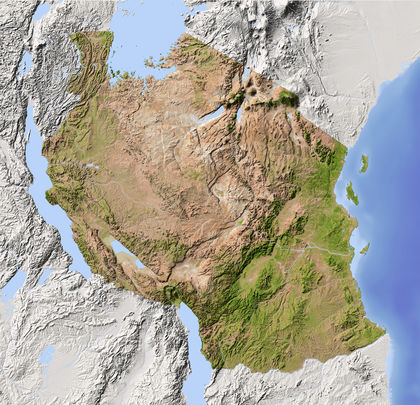
Situated in East Africa just south of the equator, mainland Tanzania lies between the area of the great lakes—Victoria, Tanganyika, and Malawi (Niassa)—and the Indian Ocean. It contains a total area of 945,087 sq km (364,900 sq mi), including 59,050 sq km (22,799 sq mi) of inland water. Comparatively, the area occupied by Tanzania is slightly larger than twice the size of the state of California. It is bounded on the N by Uganda and Kenya, on the E by the Indian Ocean, on the S by Mozambique and Malawi, on the SW by Zambia, and on the W by Zaire, Burundi, and Rwanda, with a total boundary length of 4,826 km (2,999 mi), of which 1,424 km (885 mi) is coastline. Tanzania claims part of Lake Malawi, although its internationally recognized boundary is the eastern shore.
The section of the United Republic known as Zanzibar comprises the islands of Zanzibar and Pemba and all islets within 19 km (12 mi) of their coasts, as well as uninhabited Latham Island, 58 km (36 mi) south of Zanzibar Island. Zanzibar Island lies 35 km (22 mi) off the coast, and Pemba Island is about 40 km (25 mi) to the NE . The former has an area of 1,657 sq km (640 sq mi), and the latter 984 sq km (380 sq mi).
Tanzania's capital city, Dar es Salaam, is located on the Indian Ocean coast.